Latest Post
Showing posts with label WEATHER FORECAST. Show all posts

NOAA’s investments in weather models and partnerships paying off

Written By Unknown on Tuesday, February 3, 2015 | 2:24 AM

Early improvements effective in forecasting recent Nor’easter; future forecast model upgrades planned
As the Northeast digs out from this week’s blizzard, a new NOAA-led effort to improve the forecasting of such high impact weather events is reaching an important early benchmark. One of the first major improvements - upgrading the resolution of three global forecast models -- has already shown its effectiveness. One of these models, the newly upgraded Global Forecast System (GFS) model, provided one of the most precise forecasts of the track, intensity, precipitation, and distribution of the Nor’easter. The other research models provided important forecast information, as well.

“The Global Forecast System did remarkably well in the recent Nor’easter,” said Louis Uccellini, director of NOAA’s National Weather Service. “This is due to the recent improvements we’ve made to the GFS, including higher resolution, improved physics, and better access to new data. With the help of scientists at NOAA Research, we’re making improvements to all our models, and upgrading supercomputers to improve our ability to translate data into actionable information, and to produce more timely, accurate and reliable forecasts.”

By the end of January, the $13 million project called the High Impact Weather Prediction Project (HIWPP), funded by Congress in the wake of Hurricane Sandy, will have improved the resolution on the global forecast model operated by NOAA Research Earth System Research Laboratory and the model operated by the U.S. Navy.
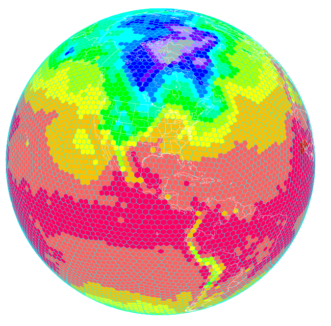
Improving global models
Scientists at NOAA’s Earth System Research Laboratory are running a high resolution global forecast model called the FIM, or Flow following finite volume Icoschedral Model. As depicted here, the FIM uses a unique grid that allows for a more uniform representation of the Earth. Higher resolution models are helping improve severe weather prediction. (NOAA)

In addition, NOAA researchers have written and installed programs to enable these three global models to work together effectively, which provides greater accuracy and confidence in forecasts. The third improvement is a plan to actively involve the broader weather forecasting community, including other public, academic and private sector scientists, in the evaluation of how these models work together to refine and improve forecasts.

“We are always looking for ways to improve the reliability and accuracy of our forecasts and models,” said John Cortinas, director of NOAA’s Office of Weather and Air Quality, who is overseeing HIWPP, which involves researchers from NOAA’s Oceanic and Atmospheric Research, NOAA’s National Weather Service, cooperative institutes, other government and academic partners.

“The goal of the project is to develop the next generation of weather forecast models that will eventually extend our ability to skillfully forecast high-impact weather out to several weeks and beyond,” Cortinas said. “By extending lead time for forecasts on storms like the one we’ve just experienced, cities and towns can better plan for these events, potentially saving lives and helping protect valuable land, homes and businesses. Businesses and industry can better plan everything from shipping to safe routing of air traffic to energy consumption. For ordinary citizens, it will be easier to plan an event or a trip.”

Over the last decades, weather forecasts have improved steadily so that we now have accurate forecasts out to five days, with reasonable accuracy to seven days. “We’ve gained about a day a decade in accuracy,” said Timothy Schneider, a research meteorologist at NOAA’s Earth System Research Laboratory, who is working to improve global forecast models. “Gaining a day of accuracy involves a combination of improving the science, adding computer power and increasing the necessary observations. With this project, we’re trying to accelerate this progress to make quicker gains.”

Global weather data key to improved local forecasts

“We know we can get better weather forecasts by improving the resolution of global forecast models so they depict weather in finer and finer detail,” explained Schneider. The resolution of NOAA’s two global forecast models has improved from grids that are 24 kilometers, to ones that are about 13 kilometers.  “The finer you chop up the picture, the more you can see of what is happening inside a particular storm. This helps us make better forecasts.”

 “If we’re going to predict weather out beyond seven and 10 days, we need even better global weather forecast models that show us what’s occurring on the other side of the Earth,” added Schneider. “Weather patterns on one side of the globe travel around the Earth and evolve. Storms born in the western Pacific follow air patterns that can create major winter storms on the West Coast, and weather patterns off the coast of Africa can spawn hurricanes in the U.S.”

Source: NOAA

NCDC Releases 2014 U.S. Climate Report

Written By Unknown on Monday, February 2, 2015 | 9:20 PM

The 2014 annual average contiguous U.S. temperature was 52.6°F, 0.5°F above the 20th century average. This ranked as the 34th warmest year in the 1895–2014 record. Very warm conditions dominated the West, while the Midwest and Mississippi Valley were cool.

The average contiguous U.S. precipitation was 30.76 inches, 0.82 inch above average, and ranked as the 40th wettest year in the 120-year period of record. The northern United States was wet, and the Southern Plains were dry; the national drought footprint shrank about 2 percent. 

In 2014, there were eight weather and climate disaster events with losses exceeding $1 billion each across the United States. These eight events resulted in the deaths of 53 people. The events include: the western U.S. drought, the Michigan and Northeast flooding event, five severe storm events, and one winter storm event. 

This summary from NOAA's National Climatic Data Center is part of the suite of climate services NOAA provides to government, business, academia, and the public to support informed decision making.

Source: NOAA


Building a Better Weather Forecast? SMAP May Help

Written By Unknown on Saturday, January 31, 2015 | 5:34 AM

SMAP's soil moisture measurements will help with forecasts of precipitation and temperature. Image credit: UCAR
If you were trying to forecast tomorrow's weather, you would probably look up at the sky rather than down at the ground. But if you live in the U.S. Midwest or someplace with a similar climate, one key to a better weather forecast may lie beneath your feet.

Precipitation and temperature are part of every weather forecast. Precipitation comes from clouds, clouds are formed of airborne water vapor, and vapor comes from evaporating soil moisture -- so soil moisture governs precipitation. Evaporating soil moisture also makes air cooler, so it affects temperature. In certain kinds of climate, scientists believe, soil moisture is so influential that better observations of it might improve weather forecasts. These climates are transitional: not too humid and not too dry. For example, the agriculturally productive states of the U.S. Midwest fall into that category.

"Better soil moisture observations lead to better land-atmosphere interaction in weather forecasting models and ultimately to a better prediction of temperature and precipitation," said Michael Ek, leader of the Land Hydrology Team at the Environmental Monitoring Center of the National Oceanic and Atmospheric Administration (NOAA). "Weather models need good initial observations of the land surface, or you're starting from the wrong place."

Better soil moisture observations are just what the Soil Moisture Active Passive (SMAP) mission will provide. Scheduled for launch on Jan. 29, SMAP will collect the most accurate and highest-resolution soil moisture measurements ever made from a satellite SMAP will cover the entire globe in two to three days. Ek is a member of one of five groups in SMAP's Early Adopter program that have been working for several years on the question of how best to incorporate the new data into national weather forecasting models.

Forecasts will not improve, however, the moment SMAP starts collecting data. U.S. Department of Agriculture research scientist Wade Crow, a member of SMAP's science team, explained that, since closely spaced global soil moisture measurements have never existed before, the mathematical models used in weather forecasting are not configured to include them directly. Getting the best use out of the new observations has been a subject of active research for several years and will require some significant changes in how soil moisture data are assimilated into the models.

Data assimilation is necessary because weather forecasting models all drift a bit, like cars. If you're driving on a perfectly straight road, you still need to keep a hand on the steering wheel or you'll run off the edge sooner or later. Data assimilation in a model serves the same purpose as the slight movements of your hands that keep your car on course.

Drift is not a fatal flaw for a weather forecasting model any more than it is for a car. It is simply a sign that the Earth system is too vast and complicated to model perfectly with the resources available today. To steer forecasts toward greater realism, models ingest, or assimilate, real-world data and use them in sophisticated mathematical techniques. Each time updated observations become available, they are assimilated to improve the starting point for the next forecast.

Closely spaced and highly accurate global measurements are an important part of the process. For soil moisture, however, current observations are not on a fine enough scale to meet the needs of weather forecasting models directly. "Modelers compensate for the lack of direct observations of soil moisture by using more indirect measures, such as estimating it from observations of temperature and precipitation," Crow explained. "As a consequence, modeled soil moisture tends to diverge from reality. SMAP will be directly observing the state that they want, so they won't have to back it out from proxy measurements."

JPL scientist Eni Njoku is working with researchers at another forecasting center, the European Centre for Medium-Range Weather Forecasts (ECMWF) in Reading, England. Njoku said, "SMAP will provide benefits of higher soil moisture accuracy and spatial resolution than have previously been available from satellites. This could lead potentially to improved regional and global weather forecasts by ECMWF." Environment Canada, the branch of the Canadian government responsible for weather forecasting in that nation, is also working on assimilating SMAP data into its models.

"The numerical weather prediction centers are adapting to the new availability of soil moisture information and thinking of ways they can exploit it," Crow summarized. "It will be really exciting to see what they find."

SMAP is managed for NASA's Science Mission Directorate in Washington by the agency's Jet Propulsion Laboratory in Pasadena, California, with instrument hardware and science contributions made by NASA's Goddard Space Flight Center in Greenbelt, Maryland. JPL is responsible for project management, system engineering, radar instrumentation, mission operations and the ground data system. Goddard is responsible for the radiometer instrument. Both centers collaborate on science data processing and delivery to the Alaska Satellite Facility, in Fairbanks, and the National Snow and Ice Data Center, at the University of Colorado in Boulder, for public distribution and archiving. NASA's Launch Services Program at the agency's Kennedy Space Center in Florida is responsible for launch management. JPL is managed for NASA by the California Institute of Technology in Pasadena.

Source: Nasa
 
Support : Creating Website | Johny Template | Mas Template
Copyright © 2011. The planet wall - All Rights Reserved
Template Created by Easy Blogging Published by Mas Template
Proudly powered by Blogger