Latest Post
Showing posts with label OCEAN. Show all posts

The 500 million years ocean history

Written By Unknown on Monday, February 9, 2015 | 12:18 AM

Brachiopod Paraspirifer bownockeri from the Middle Devonian of Ohio (USA); Width: 5.6 cm. Picture: U. Jansen, Senckenberg Museum, Frankfurt am Main.

GEOMAR coordinates European research and education project BASE-LiNE Earth
02.03.2015 / Kiel. As the history of the oceans can be reconstructed in the past 500 million based on calcareous shells of fossil marine life, busy to date with the research project BASE-LiNE Earth. At the same time it enables talented young scientists and scientists a doctorate in an international research environment. The European Union supports the at GEOMAR Helmholtz Centre for Ocean Research Kiel coordinated project with a total of 3.8 million euros.

Almost all life on earth would be extinct - and that at least five times in the past 500 million years. The environmental changes that have each led to the mass extinction, the oceans play an important role in almost all cases. How did it happen that was phased so hostile to life as a life-giving force sea? And why have some species still survive? These are fundamental questions that will be examined in the next three years as part of the European research project BASE-LiNE Earth with innovative technologies and methods. In addition to answering the research questions BASE LiNE Earth serves as the training of talented young scholars and scientists who are recruited by means of a demanding selection process from all over the world and doctorate within the scope of the project. 

The EU promotes the GEOMAR Helmholtz Centre for Ocean Research Kiel coordinated project under a Marie Skłodowska-Curie Action in Horizon2020-Pogramm with a total of 3.8 million euros. The challenge for the future BASE-LiNE Earth-doctoral students, is to provide information to gain from distant epochs of earth's history. "When historians want to know about events 100 or 200 years ago, they visit libraries or archives where there is written evidence from these times," says project coordinator Prof. Dr. Anton Eisenhauer from GEOMAR. "We also use archives. 
However, they see something different. It is, for example, the calcareous shells of fossil brachiopods in which the relevant data on the chemical history of ocean water are stored reliably, "explains the Kiel geochemist on. 

The information is in the calcite shells of course not writing before, but encrypted in the chemical and mineralogical composition. "If we precise the ratios of elements such as strontium, magnesium, boron, or measure of the isotopic to each other, we can decrypt the information," says Professor Eisenhauer.

This then the age of the shell, as well as the chemical composition of the previous ocean and prevailing environmental conditions such as water temperature and the acidity of the water can be reconstructed. We know, for example, know that during the greatest mass extinction 251 million years ago, the ocean contained no oxygen and was acidified to a large extent. 

"This is similar to some scenarios that we expect for the future of our ocean," explains Professor Eisenhauer. Model calculations are carried out within the framework of the project should show how far the former changes in the environment are transferable to the present day. The challenge is to gain this information and to make it usable. In collaboration with industry partners modern analytical methods for obtaining information in cooperation with business partners in this area in the context of BASE-LiNE Earth therefore be generated and developed. The project involves a total of 21 scientific institutions from eight European countries and partners from Canada, Israel, Palestine and Australia involved. 15 PhD positions will announce the project this spring, two of them for the GEOMAR in Kiel. 

The Integrated School of Ocean Sciences (ISOS) provides at the University of Kiel for a comprehensive training program in which the scholars not only pursue their academic goals, but also learn more professional qualifications, skills and interact with each other.  In the coming years, the parties want to do their topic also by means of exhibitions and school supplies to a wider audience. "Of course we also bind the doctoral students, which thus also learn to communicate their work understandable," says the project coordinator. For more information on the project website www.baseline-earth.eu.

Source: Geomar

Deep Sea Mining: What are the risks?

Written By Unknown on Sunday, February 8, 2015 | 7:43 PM

During the launch event in Kiel, the project partners plan investigations to ecosystems around the manganese nodules. Photo: J. Steffen, GEOMAR

GEOMAR coordinates European cooperation for the risk assessment
01.29.2015 / Kiel. 50 specialists in deep-sea ecology, marine mining and deep-sea observation of 25 European research institutions meeting this week at the GEOMAR Helmholtz Centre for Ocean Research Kiel. This will free the start of a three-year research project to investigate the risks of potential ore mining on the seabed. The project called "JPI Oceans Ecological aspects of deep-sea mining" is coordinated at GEOMAR.

The world population is growing. This also means that more and more people need a home, want to work with computers and other electronic devices and consume energy. For the construction of houses for the manufacture of electronic goods, but also for the production of wind turbines will require significant amounts of various metals. Currently, all metal ores are promoted on almost a third of the earth's surface - on the continents. 
In some regions of the ocean manganese nodules are recorded in the Atlantic as here, close together on the ocean floors. Photo: Nils Brenke, CeNak

However, in recent decades engaged again, the other two thirds, the oceans, the focus of governments and resource companies. "Many questions about a potential ore mining in the deep sea, however, are still open," says Dr. Matthias Haeckel from GEOMAR Helmholtz Centre for Ocean Research Kiel. He is the scientific coordinator of the "Ecological aspects of deep-sea mining" project to investigate the potential environmental risks in the next three years. A consortium of research ministries in eleven European countries promotes it as part of the Joint Programme Healthy and Productive Seas (JPI Oceans) initiative with a total of 9.5 million euros. 
In the Clarion-Clipperton Zone are the largest known manganese nodule deposits. Here, the ISA has been awarded 13 research licenses. Image Reproduced from the GEBCO world map 2014 www.gebco.net,
 In the Clarion-Clipperton Zone are the largest known manganese nodule deposits. Here, the ISA has been awarded 13 research licenses. Image Reproduced from the GEBCO world map 2014

This week, the project starts with a kick-off meeting at GEOMAR. A total of 25 partner institutions from these eleven countries involved in the project. The focus is primarily known as manganese nodules. It is spherical or cauliflower-shaped Erzknollen, which are usually at depths below 4000 meters on the large abyssal plains. They consist not only from the eponymous manganese, but also contain iron and coveted metals such as copper, cobalt or nickel. Already in the 1970s, there were initial plans to reduce manganese nodules from the deep sea, but never came out on trials. The largest reserves are currently known from the Clarion-Clipperton Fracture Zone in the central Pacific. As a result of these activities in international waters on the basis of the International Law of the Sea (UNCLOS), the International Seabed Authority (International Seabed Authority, ISA) was founded in 1994. 

It manages the entire seabed beyond the exclusive economic zone (200 nautical miles) of individual states. To date, the ISA has awarded 13 research licenses for exploration of manganese nodule fields in the Pacific, including in Germany and other European countries. 
Sample of the seabed in DISCOL area with top resting manganese nodules.
                     Sample of the seabed in DISCOL area with top resting manganese nodules. 
                                                    Photo: M. Haeckel, GEOMAR

"But there is no mining licenses, which would only be a next step," said Dr. Haeckel. Since the ISA also aims to ensure effective protection of the marine environment from the potential consequences of ocean mining, relevant research for the licensees are required. "Of course industrial activities on the ocean floor will have an impact, because they disturb the soil and the water column about it," says Dr. Haeckel. Therefore, it is important to know the ecosystems on the sea floor and its local, regional and national connections and interactions accurately. Already this year, several expeditions of the new German research vessel SONNE in the Pacific are planned. 

The first trips in March and April perform the participating scientists to the German, Belgian and French license areas and in a defined by the ISA reserve in the Clarion-Clipperton Zone. Further trips from July to October have the so-called DISCOL area in Peru Basin to the destination. There, in 1989, a very limited area of the seabed was plowed for research purposes. "The goal of this experiment is to recognize the long-term consequences of large-area device used for deep-sea sediments," explains Professor Jens Greinert from GEOMAR, who will lead one of the exits to DISCOL area. Now, a quarter century after the disturbance experiment, the scientists will examine the then machined seabed areas exactly compare with adjacent undisturbed areas to determine, can recover disturbed communities in the deep sea as fast. "We should get to know each other better before we start, a large area to intervene in the deep sea it easy," says project coordinator Dr. Haeckel. 

Source: GEOMAR

NOAA’s investments in weather models and partnerships paying off

Written By Unknown on Tuesday, February 3, 2015 | 2:24 AM

Early improvements effective in forecasting recent Nor’easter; future forecast model upgrades planned
As the Northeast digs out from this week’s blizzard, a new NOAA-led effort to improve the forecasting of such high impact weather events is reaching an important early benchmark. One of the first major improvements - upgrading the resolution of three global forecast models -- has already shown its effectiveness. One of these models, the newly upgraded Global Forecast System (GFS) model, provided one of the most precise forecasts of the track, intensity, precipitation, and distribution of the Nor’easter. The other research models provided important forecast information, as well.

“The Global Forecast System did remarkably well in the recent Nor’easter,” said Louis Uccellini, director of NOAA’s National Weather Service. “This is due to the recent improvements we’ve made to the GFS, including higher resolution, improved physics, and better access to new data. With the help of scientists at NOAA Research, we’re making improvements to all our models, and upgrading supercomputers to improve our ability to translate data into actionable information, and to produce more timely, accurate and reliable forecasts.”

By the end of January, the $13 million project called the High Impact Weather Prediction Project (HIWPP), funded by Congress in the wake of Hurricane Sandy, will have improved the resolution on the global forecast model operated by NOAA Research Earth System Research Laboratory and the model operated by the U.S. Navy.
Improving global models
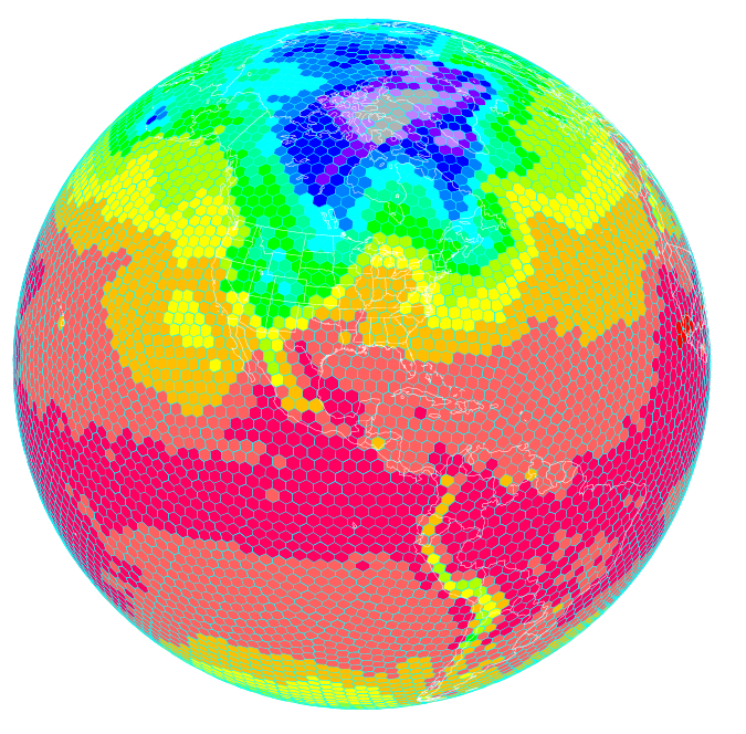
Scientists at NOAA’s Earth System Research Laboratory are running a high resolution global forecast model called the FIM, or Flow following finite volume Icoschedral Model. As depicted here, the FIM uses a unique grid that allows for a more uniform representation of the Earth. Higher resolution models are helping improve severe weather prediction. (NOAA)

In addition, NOAA researchers have written and installed programs to enable these three global models to work together effectively, which provides greater accuracy and confidence in forecasts. The third improvement is a plan to actively involve the broader weather forecasting community, including other public, academic and private sector scientists, in the evaluation of how these models work together to refine and improve forecasts.

“We are always looking for ways to improve the reliability and accuracy of our forecasts and models,” said John Cortinas, director of NOAA’s Office of Weather and Air Quality, who is overseeing HIWPP, which involves researchers from NOAA’s Oceanic and Atmospheric Research, NOAA’s National Weather Service, cooperative institutes, other government and academic partners.

“The goal of the project is to develop the next generation of weather forecast models that will eventually extend our ability to skillfully forecast high-impact weather out to several weeks and beyond,” Cortinas said. “By extending lead time for forecasts on storms like the one we’ve just experienced, cities and towns can better plan for these events, potentially saving lives and helping protect valuable land, homes and businesses. Businesses and industry can better plan everything from shipping to safe routing of air traffic to energy consumption. For ordinary citizens, it will be easier to plan an event or a trip.”

Over the last decades, weather forecasts have improved steadily so that we now have accurate forecasts out to five days, with reasonable accuracy to seven days. “We’ve gained about a day a decade in accuracy,” said Timothy Schneider, a research meteorologist at NOAA’s Earth System Research Laboratory, who is working to improve global forecast models. “Gaining a day of accuracy involves a combination of improving the science, adding computer power and increasing the necessary observations. With this project, we’re trying to accelerate this progress to make quicker gains.”

Global weather data key to improved local forecasts

“We know we can get better weather forecasts by improving the resolution of global forecast models so they depict weather in finer and finer detail,” explained Schneider. The resolution of NOAA’s two global forecast models has improved from grids that are 24 kilometers, to ones that are about 13 kilometers.  “The finer you chop up the picture, the more you can see of what is happening inside a particular storm. This helps us make better forecasts.”

 “If we’re going to predict weather out beyond seven and 10 days, we need even better global weather forecast models that show us what’s occurring on the other side of the Earth,” added Schneider. “Weather patterns on one side of the globe travel around the Earth and evolve. Storms born in the western Pacific follow air patterns that can create major winter storms on the West Coast, and weather patterns off the coast of Africa can spawn hurricanes in the U.S.”

Source: NOAA

The science behind swimming: From whales to larvae, common principles at work in swimming

Written By Unknown on Wednesday, December 24, 2014 | 5:11 PM

Whale and diver (stock illustration). Using simple hydrodynamics, researchers were able to show that a handful of principles govern how virtually every animal -- from the tiniest fish to birds to gigantic whales propel themselves though the water. Credit: © James Thew / Fotolia
At nearly 100 feet long and weighing as much as 170 tons, the blue whale is the largest creature on the planet, and by far the heaviest living thing ever seen on Earth. So there's no way it could have anything in common with the tiniest fish larvae, which measure millimeters in length and tip the scales at a fraction of a gram, right?

Not so fast, says L. Mahadevan, the Lola England de Valpine Professor of Applied Mathematics, of Organismic and Evolutionary Biology, and of Physics.

Using simple hydrodynamics, a team of researchers led by Mahadevan was able to show that a handful of principles govern how virtually every animal -- from the tiniest fish to birds to gigantic whales propel themselves though the water. The study is described in a September 14 paper in Nature Physics.

"What we wanted to investigate was how the speed of an organism changes as a function of how large it is, how quickly it moves and how much it moves," Mahadevan said. "To resolve that in detail, however, is very complex, because there is a great deal of differences in morphology and what parts of the body different creatures use to swim. The question is: Is there anything in common across all these organisms? The answer, we found, is yes."

In an effort to uncover those common principles, Mahadevan working with a postdoctoral fellow in his group , Mattia Gazzola, and a colleague Mederic Argentina from the University of Nice, began by trying to unpack the physics of how different creatures swim.

"The traditional approach to swimming phenomena is to take a certain specimen and accurately characterize it via experiments and/or simulations, and try to generalize from there, but it is very hard to strip out specific biological effects from general principles," Gazzola said. "We instead thought that while swimmers exhibit a huge diversity in shapes and kinematics, at the end of the day they all live in the same media, water.

"Therefore we thought that if a unifying mechanistic principle existed, it had to lie in the constraints that the flow environment poses to all its inhabitants," he continued. "And this is a purely physical problem, much easier to solve since it is not affected by biological vagaries. What I like about this paper is that in one line of algebra we derived a compact formula that accounts for 50 years of experiments. This is an example of how powerful minimal modeling can be."

"The basic relationship we wanted to understand was how the input variables -- namely the size of the organism, the amount an organism moves and how quickly it moves -- control the output variable, which is effectively the speed at which it moves," Mahadevan explained. "What we found is that there is a specific relationship, which can be described by in terms of a simple scaling law with two limits."

The first, which corresponds to creatures moving at intermediate speeds, describes situations where the bulk of the resistance is caused by skin friction, because water "sticks" to the organism's body. At faster speeds, Mahadevan said, the resistance organisms face largely comes from pressure that builds up in front of and around them, which is described by the second limit.

"While it wasn't a surprise that the resistance changed at organisms moved faster, the fact that those challenges could be so simply described was interesting and provocative, because we are talking about organisms that range in size from a few millimeters to the size of a blue whale," Mahadevan said.

Armed with those observations, Mahadevan and colleagues turned to a host of empirical observations that had been made over the past 50-plus years. When those data were plotted on a graph, the researchers found that the swimming speed of virtually every organism, from fish larvae to frogs to birds, amphibians and even whales, could be described by one of the two equations.

The same also held true, Mahadevan said, when Gazzola created complex computer models to solve the governing equations of fluid dynamics to describe how different organisms swim.

"What is particularly interesting is that all the organisms essentially reach the hydrodynamic limits of performance," he said. "Our simple theory, which doesn't distinguish in any detailed way between something like a blue whale and fish larvae, except in the parameters of how large you are, much you move and how quickly you move, can describe all this diversity. That suggests there are general principles at work here."


Source: Harvard University

Tailor-made for the aquaculture sector

Written By Unknown on Tuesday, December 23, 2014 | 3:55 AM

Details are important. The hood is specially adapted for personnel wearing helmets – without compromising vision. Credit: SINTEF Health Research
Fish husbandry workers have played an active part in developing work clothing tailor-made for their wet, windy and messy working conditions.

They're standing in a small circle around a net pen out in the ocean. Their job is to maintain the net pens, de-louse the salmon, and carry out the many other tasks essential to the running of a fish farm facility. The wind is bitter and the rain is lashing in from all directions. Sea water is splashing around their feet. Everything they handle is wet. Cold water creeps relentlessly up to their knees and along to their elbows inside their coveralls, which are only waterproof up until the second wash.

This is a normal working day for a couple of thousand workers in fish farms all along the Norwegian coast. In spite of this no work clothing exists that is specifically adapted to their very special working conditions. Yet.

Industrial designers Tore Christian Bjørsvik Storholmen and Ole Petter Næsgaard at SINTEF Health Research have developed work clothing which they hope will make conditions both safer and more comfortable for husbandry workers out on the fish farms. Their project has been carried out in close collaboration with the workers who will be wearing the clothing.

Better together

"We've spent a lot of time getting to know the business and the needs of the husbandry workers," says Næsgaard. "We've taken part in many tasks, observed what goes on, and have obtained input and feedback in response to our suggestions," he says. "We've met with a thoroughly honest group of people. They don't hold back when they're not satisfied," he says.

They visited three different facilities close to Hitra and Frøya as part of a pilot project. Ideas and sketches made during one visit were taken to the next so that they could encourage reactions and get feedback. It has been an iterative process involving an ongoing series of corrections and improvements.

"This has served as a quality control on our work to develop relevant and attractive solutions," says Storholmen. "We could never have put the first prototype on the market," he says. "But our dialogue with the users has enabled continuous refinement. New details are always being developed and incorporated. "We're now getting close to a product that can be introduced to the market," he says.

Inspired by climbers and skiers

"When we were studying the husbandry workers, we saw that they do a lot of climbing from boat to boat through ropes and cables and across a variety of different barriers. This led us to obtain inspiration from clothes developed for climbers. The result is that the clothing now offers a very good fit - combined with excellent freedom of movement," explains Storholmen.

When it comes to choosing fabrics, the researchers have obtained greater inspiration from sports clothes than from other types of work clothing. Instead of thick, insulated suits, the new clothing concept has much more in common with kit worn by skiers.

"We've exploited the shell principle," says Storholmen. "The fabric of the outermost layer is water- and wind-proof and very light and durable," he says. "We've also developed intermediate layers and underwear, so users can select the clothing they need based on weather conditions and their own level of activity," he explains.

The clothing is also specifically adapted to allow good freedom of movement in the neck area - even when wearing a life vest. The same applies to the hood which has plenty of room for the mandatory helmet. What about reflective patches? These are placed strategically on the arms, hood and shoulders, and not across the shoulders and legs which is standard for the majority of existing work clothing.

"Actually, we saw that workers testing the clothing were at first sorry to have to return it following the tests," says Storholmen. "This has to be a good sign," he says.

However, the developers are not satisfied simply with anatomical adjustments, new fabrics and good visibility. There has to be a place for modern technology in this type of clothing. So the suit is equipped with a waterproof pocket for a mobile phone, and will also be fitted with a separate pocket to accommodate a man-overboard alarm.

Comfort equals effective HSE

The fish farms visited by the researchers are in exposed coastal locations, often about a half-hour's boat trip from land. The husbandry workers are housed in floating pontoons, surrounded by net pens. They may have to stay here for as much as a week at a time. There have been situations where workers have fallen into the sea. It is essential that the new work clothing represents an improvement in safety. It must be easy for the wearer to get hold of important tools such as knives, tape and communications equipment.

"An Operations Manager told us that good work clothing is one of the most important aids to effective HSE," says Storholmen. "People standing around getting cold lose concentration on what they're doing, making accidents more likely. We believe that this is thoroughly addressed by the new clothing," he says.

A net pen is an enormous "warehouse," and if a major accident occurs, the consequences for the environment and the company's profitability may be very large.

"Aquaculture uniform"

The clothing currently worn by husbandry workers is essentially the same as the standard primarily developed for the building and construction industry, where competitive pricing is a major issue. The clothing being developed in this project will probably be more expensive.

"Current work clothing is a consumer item," say the researchers. "Our impression is that there is a willingness to pay for a better and more durable product specifically adapted to the needs of the aquaculture industry - a specially designed "aquaculture uniform" which can identify the workers and promote an increase in the pride they have in their profession," they say.

Source: SINTEF

The tsunami-early warning system for the indian ocean: Ten years after

Written By Unknown on Sunday, December 21, 2014 | 10:14 PM

Technical concept of GITEWS.
The day after Christmas this year will mark the 10 anniversary of the tsunami disaster in the Indian Ocean. On 26 December 2004, a quarter of a million people lost their lives, five million required immediate aid and 1.8 million citizens were rendered homeless. The natural disaster, which caused extreme devastation over huge areas and the accompanying grief and anxiety, especially in Indonesia, Thailand and Sri Lanka exceeded the imaginable and reached such drastic dimensions, mainly due to the lack of a warning facility and a disaster management plan for the entire Indian Ocean region at this time.
Germany and the international community of states reacted with immediate support. Within the framework of the German Flood Victim Aid the Federal Government commissioned the Helmholtz Association of German Research Centres under the direction of the GFZ German Research Centre for Geosciences with the development of an Early Warning System for the Indian Ocean. From 2005 to 2011, with the large-scale project GITEWS (German-Indonesian Tsunami Early Warning System), the core of an integrated, modern, and effective Tsunami Early Warning System in Indonesia was established. With the follow-up project PROTECTS (Project for Training, Education and Consulting for Tsunami Early Warning Systems, 2011-2014) the personnel of the participating Indonesian institutions were trained to proceed independently and to take over responsibility for the operation of the Early Warning System as well as for the diverse technical and organizational components. In this ways PROTECTS which started in June 2011 and comprised a total of 192 training courses, internships, and hands-on-practice courses, covering all aspects of operation and maintenance of the Tsunami-Early Warning System contributed significantly to the sustainability of InaTEWS.
Under the auspices of the IntergovernmentalOceanographicCommission of UNESCO and with the collaboration of international partner institutes from Germany, the USA, China and Japan, GITEWS was integrated into a Tsunami Early Warning System for Indonesia. GITEWS was positively reviewed by a commission of international experts in 2010 and handed over to Indonesia in March 2011. Since then it has been providing its services under the name InaTEWS -- Indonesian Tsunami Early Warning System and is operated by the Indonesian Service for Meteorology, Climatology and Geophysics BMKG.

On 12 October 2011 the exercise drill "IOWAVE11" was carried out in the Indian Ocean. With this drill, InaTEWS successfully demonstrated that it could, furthermore, take over the role of a Regional Tsunami Service Provider (RTSP). Since then Indonesia, in addition to Australia und India, performs the double function as a National Tsunami Warning Center (NTWC) and also as a RTSP and takes over the responsibility for the timely warning of 28 states around the Indian Ocean in the event of a threatening Tsunami. With the on-going step-by-step development, a comprehensive all-encompassing InaTEWS could be successfully realized.

Indonesia now avails of one of the most modern Tsunami Early Warning Systems. On the basis of data from approx. 300 measuring stations a warning can be issued at a maximum of five minutes after an earthquake. These measuring stations include e.g. seismometers, GPS stations und coastal tide gauges. With the data gained from the sensors and using the most modern evaluation systems such as SeisComP3 which was developed by GFZ scientists for the analyses of earthquake data and a Tsunami simulation system in the Warning Centre it is possible to compile a comprehensive picture of the situation. With the aid of a decision support system respectively classified warnings for the affected coastal areas can then be issued. A total of 70 people are involved the operation of the Warning Centre in Jakarta, with 30 employees working solely in a full shift system. According to information provided by the BMKG a total of 1700 earthquakes with a magnitude of more than M= 5 and 11 quakes with a magnitude of 7 and higher have been evaluated and six Tsunami Warnings have been issued to the public by the Earthquake Monitoring and Tsunami Early Warning Centre since the hand over in March 2011.

Schooling, training and disaster precautions (capacity development) for the local community and Town and District councils have received special emphasis. This Capacity Development has been carried out since 2006 in three "typical" regions: Padang (Sumatra), Chilacap (South-Java) and Denpassar (Bali, tourist stronghold). Here particular emphasis was placed on understanding both the warnings issued and the planned evacuation measures.

Local disaster management structures are established with local decision-makers and Disaster Risk Reduction Strategies are developed. Specifically, the education of trainers who are, in turn, responsible for the further spreading of the developed concepts plays a significant role.

Another key element is the determination of hazard and risk maps as a basis for the local evacuation planning as well as for future town and land-use planning. In Bali communication with the hotel industry was an additional factor.

No Early Warning System will ever be able to prevent a strong earthquake and a resulting tsunami and also, in the future, there will be loss of life and material damage. However, through the existence of an Early Warning System and the integration of organizational measures together with comprehensive capacity building the adverse effects of such a natural disaster can certainly be reduced.

Atlantic warming turbocharges Pacific trade winds

Tropical beach (stock image). Rapid warming of the Atlantic Ocean, likely caused by global warming, has turbocharged Pacific Equatorial trade winds, according to new research. Credit: © michaelfitz / Fotolia
New research has found rapid warming of the Atlantic Ocean, likely caused by global warming, has turbocharged Pacific Equatorial trade winds. Currently the winds are at a level never before seen on observed records, which extend back to the 1860s.

The increase in these winds has caused eastern tropical Pacific cooling, amplified the Californian drought, accelerated sea level rise three times faster than the global average in the Western Pacific and has slowed the rise of global average surface temperatures since 2001.

It may even be responsible for making El Nino events less common over the past decade due to its cooling impact on ocean surface temperatures in the eastern Pacific.

"We were surprised to find the main cause of the Pacific climate trends of the past 20 years had its origin in the Atlantic Ocean," said co-lead author Dr Shayne McGregor from the ARC Centre of Excellence for Climate System Science (ARCCSS) at the University of New South Wales.

"It highlights how changes in the climate in one part of the world can have extensive impacts around the globe."

The record-breaking increase in Pacific Equatorial trade winds over the past 20 years had, until now, baffled researchers.

Originally, this trade wind intensification was considered to be a response to Pacific decadal variability. However, the strength of the winds was much more powerful than expected due to the changes in Pacific sea surface temperature.

Another riddle was that previous research indicated that under global warming scenarios Pacific Equatorial Trade winds would slow down over the coming century.

The solution was found in the rapid warming of the Atlantic Ocean basin, which has created unexpected pressure differences between the Atlantic and Pacific. This has produced wind anomalies that have given Pacific Equatorial trade winds an additional big push.

"The rapid warming of the Atlantic Ocean created high pressure zones in the upper atmosphere over that basin and low pressure zones close to the surface of the ocean," said Prof Axel Timmermann co-lead and corresponding author from the University of Hawaii.

"The rising air parcels, over the Atlantic eventually sink over the eastern tropical Pacific, thus creating higher surface pressure there. The enormous pressure see-saw with high pressure in the Pacific and low pressure in the Atlantic gave the Pacific trade winds an extra kick, amplifying their strength. It's like giving a playground roundabout an extra push as it spins past."

Many climate models appear to have underestimated the magnitude of the coupling between the two ocean basins, which may explain why they struggled to produce the recent increase in Pacific Equatorial trade wind trends.
While active, the stronger Equatorial trade winds have caused far greater overturning of ocean water in the West Pacific, pushing more atmospheric heat into the ocean, as shown by co-author and ARCCSS Chief Investigator Prof Matthew England earlier this year. This increased overturning appears to explain much of the recent slowdown in the rise of global average surface temperatures.
Importantly, the researchers don't expect the current pressure difference between the two ocean basins to last. When it does end, they expect to see some rapid changes, including a sudden acceleration of global average surface temperatures.

"It will be difficult to predict when the Pacific cooling trend and its contribution to the global hiatus in surface temperatures will come to an end," Prof England said.

"However, a large El Niño event is one candidate that has the potential to drive the system back to a more synchronized Atlantic/Pacific warming situation."

Source: University of New South Wales

Long-running Jason-1 ocean satellite takes final bow

Artist's concept of the joint NASA/CNES Jason-1 ocean altimetry satellite. During its 11-1/2-year life, Jason-1 helped create a 20-plus-year climate record of global ocean surface topography, providing new insights into ocean circulation, tracking our rising seas and enabling more
The curtain has come down on a superstar of the satellite oceanography world that played the "Great Blue Way" of the world's ocean for 11-1/2 years. The successful joint NASA and Centre National d'Etudes Spatiales (CNES) Jason-1 ocean altimetry satellite was decommissioned this week following the loss of its last remaining transmitter.
Launched Dec. 7, 2001, and designed to last three to five years, Jason-1 helped create a revolutionary 20-plus-year climate data record of global ocean surface topography that began in 1992 with the launch of the NASA/CNES Topex/Poseidon satellite. For more than 53,500 orbits of our planet, Jason-1 precisely mapped sea level, wind speed and wave height for more than 95 percent of Earth's ice-free ocean every 10 days. The mission provided new insights into ocean circulation, tracked our rising seas and enabled more accurate weather, ocean and climate forecasts.
"Jason-1 has been a resounding scientific, technical and international success," said John Grunsfeld, associate administrator of NASA's Science Mission Directorate in Washington. 

"The mission met all of its requirements, performed an extended mission and demonstrated how a long-term climate data record should be established from successively launched satellites. Since launch, it has charted nearly 1.6 inches (4 centimeters) of rise in global sea levels, a critical measure of climate change and a direct result of global warming. The Jason satellite series provides the most accurate measure of this impact, which is felt all over the globe."

During parts of its mission, Jason-1 flew in carefully coordinated orbits with both its predecessor Topex/Poseidon and its successor, the Ocean Surface Topography Mission/Jason-2, launched in 2008. These coordinated orbit periods, which lasted about three years each, cross-calibrated the satellites, making possible a 20-plus-year unbroken climate record of sea level change. These coordination periods also doubled data coverage.

Combined with data from the European Space Agency's Envisat mission, which also measured sea level from space, these data allow scientists to study smaller-scale ocean circulation phenomena, such as coastal tides, ocean eddies, currents and fronts. These small-scale features are thought to be responsible for transporting and mixing heat and other properties, such as nutrients and dissolved carbon dioxide, within the ocean.

"Jason-1 was an exemplary and multi-faceted altimeter mission and contributed so much to so many scientific disciplines," said Jean-Yves Le Gall, CNES president in Paris. "Not only did Jason-1 extend the precise climate record established by Topex/Poseidon, it made invaluable observations for mesoscale ocean studies on its second, interleaved orbit. Even from its 'graveyard' orbit, Jason-1 continued to make unprecedented new observations of the Earth's gravity field, with precise measurements right till the end."

The in-orbit Jason-2 mission, operated by the meteorological agencies of the United States and Europe (the National Oceanic and Atmospheric Administration and EUMETSAT, respectively) in collaboration with NASA and CNES, is in good health and continues to collect science and operational data. This same U.S./European team is preparing to launch the next satellite in the series, Jason-3, in March 2015.

Contact was lost with the Jason-1 satellite on June 21 when it was out of visibility of ground stations. At the time of the last contact, Jason-1 and its instruments were healthy, with no indications of any alarms or anomalies. Subsequent attempts to re-establish spacecraft communications from U.S. and French ground stations were unsuccessful. Extensive engineering operations undertaken to recover downlink communications also were unsuccessful.

After consultation with the spacecraft and transmitter manufacturers, it was determined a non-recoverable failure with the last remaining transmitter on Jason-1 was the cause of the loss of contact. The spacecraft's other transmitter experienced a permanent failure in September 2005. There now is no remaining capability to retrieve data from the Jason-1 spacecraft.
On July 1, mission controllers commanded Jason-1 into a safe hold state that reinitialized the satellite. After making several more unsuccessful attempts to locate a signal, mission managers at CNES and NASA decided to proceed with decommissioning Jason-1. The satellite was then commanded to turn off its magnetometer and reaction wheels. Without these attitude control systems, Jason-1 and its solar panels will slowly drift away from pointing at the sun and its batteries will discharge, leaving it totally inert within the next 90 days. The spacecraft will not reenter Earth's atmosphere for at least 1,000 years.
"Like its predecessor Topex/Poseidon, Jason-1 provided one of the most comprehensive pictures of changes in the tropical Pacific Ocean, including the comings and goings of El Nino and La Nina events," said Lee-Lueng Fu, Jason-1 project scientist at NASA's Jet Propulsion Laboratory in Pasadena, Calif. "These Pacific Ocean climate cycles are responsible for major shifts in sea level, ocean temperatures and rainfall every two to five years and can sometimes be so large that worldwide weather patterns are affected. Jason-1 data have been instrumental in monitoring and predicting these ever-changing cycles."
In the spring of 2012, based on concern over the limited redundancy of Jason-1's aging control systems, NASA and CNES moved the satellite into its planned final "graveyard" orbit, depleted its extra fuel and reconfigured the mission to make observations that will improve our knowledge of Earth's gravity field over the ocean, in addition to delivering its oceanographic data products.

The first full 406-day marine gravity mission was completed on June 17. The resulting data have already led to the discovery of numerous small seamounts, which are underwater mountains that rise above the deep-sea floor. The data also have significantly increased the resolution of Earth's gravity field over the ocean, while increasing our knowledge of ocean bathymetry, which is the underwater depth of the ocean floor.

JPL manages the U.S. portion of the Jason-1 mission for NASA's Science Mission Directorate. CNES manages the French portion of the mission.

Intensity of hurricanes: New study helps improve predictions of storm intensity

Rough sea with big waves (stock image). "The air-water interface -- whether it had significant waves or significant spray -- is a big factor in storm intensity," said Alex Soloviev, Ph.D., a professor at Nova Southeastern University's Oceanographic Center. "Hurricanes gain heat energy through the interface and they lose mechanical energy at the interface." Credit: © mimadeo / Fotolia
They are something we take very seriously in Florida -- hurricanes. The names roll off the tongue like a list of villains -- Andrew, Charlie, Frances and Wilma.

In the past 25 years or so, experts have gradually been improving prediction of the course a storm may take. This is thanks to tremendous advancements in computer and satellite technology. While we still have the "cone of uncertainty" we've become familiar with watching television weather reports, today's models are more accurate than they used to be.

The one area, however, where there is still much more to be researched and learned is in predicting just how intense a storm may be. While hurricane hunter aircraft can help determine wind speed, velocity, water temperature and other data, the fact is we often don't know why or how a storm gets stronger or weaker. There has been virtually no progress in hurricane intensity forecasting during the last quarter century.

But, thanks to new research being conducted, all that's about to change.

"The air-water interface -- whether it had significant waves or significant spray -- is a big factor in storm intensity," said Alex Soloviev, Ph.D., a professor at Nova Southeastern University's Oceanographic Center. "Hurricanes gain heat energy through the interface and they lose mechanical energy at the interface."

Soloviev is also an Adjunct Professor at the University of Miami Rosenstiel School of Marine and Atmospheric Science (UM RSMAS) and a Fellow at the Cooperative Institute for Marine and Atmospheric Studies (CIMAS.) He and his fellow researchers used a computational fluid dynamics model to simulate microstructure of the air-sea interface under hurricane force winds. In order to verify these computer-generated results, the group conducted experiments at the UM's Rosenstiel School Air-Sea Interaction Salt Water Tank (ASIST) where they simulated wind speed and ocean surface conditions found during hurricanes.
The study "The Air-Sea Interface and Surface Stress Under Tropical Cyclones" was published in the June 16, 2014 issue of the journal Nature Scientific Reports. Soloviev was the lead author of this study, which was conducted by a multi-institutional team including Roger Lukas (University of Hawaii), Mark Donelan and Brian Haus (UM RSMAS), and Isaac Ginis (University of Rhode Island.)
The researchers were surprised at what they found. Under hurricane force wind, the air-water interface was producing projectiles fragmenting into sub millimeter scale water droplets. This process is known from some engineering applications, including rocket science, as the Kelvin-Helmholtz (KH) instability. This new study then looked at how changes in microphysics of the air-sea interface can make a storm grow or weaken in intensity. With wind speed exceeding a Category 1 threshold, the ocean surface unexpectedly became more "slippery."

When the wind exceeded Category 3 hurricane force, the "slippery" effect started gradually disappearing and was completely gone at Category 5. The conclusion was that some hurricanes might rapidly intensify to Category 3 and then stay in a "comfortable" zone around Category 3 status. This finding is consistent with the global best-track tropical cyclone statistics on maximum intensity for 1982-2009. So far, these early results showed that physical conditions where the air and the ocean interact must be a vital part of any successful hurricane forecasting model and would help explain, and predict, how a storm might intensify as it moves through across the water based on the physical stress at the ocean's surface.

This work has been supported by the NOPP project "Advanced coupled atmosphere-wave-ocean modeling for improving tropical cyclone prediction models" (PIs: Isaac Ginis, URI and Shuyi Chen, UM) and by the Gulf of Mexico Research Initiative (GoMRI) Consortium for Advanced Research on the Transport of Hydrocarbons in the Environment -- CARTHE (PI: Tamay Özgökmen, UM). GoMRI is a 10-year, $500 million independent research program established by an agreement between BP and the Gulf of Mexico Alliance.

The plan is for the team to continue their research and experiments at UM's Alfred C. 

Glassell, Jr. SUSTAIN facility, which has recently been designed by one of the Nature article co-authors, Brian Haus (UM). It's the unique lab facility where they can recreate the conditions found in a Category 5 storm.

"We've got more work to do, but this is a great first step," Soloviev said. "But remember, no matter how good we get in predicting a storm's intensity, people in the path need to prepare accordingly regardless of what Category it is -- that's most important."

Source: Nova Southeastern University

Scientists estimate total weight of plastic floating in world's oceans: Nearly 269,000 tons of plastic pollution floating in the ocean

Written By Unknown on Friday, December 19, 2014 | 9:37 PM

Model results for global count density in four size classes. Model prediction of global count density (pieces km−2; see colorbar) for each of four size classes (0.33–1.00 mm, 1.01–4.75 mm, 4.76–200 mm, and >200 mm). Credit: Marcus Eriksen et al, PLoS ONE, 2014; DOI: 10.1371/journal.pone.0111913
Nearly 269,000 tons of plastic pollution may be floating in the world's oceans, according to a study published December 10, 2014 in the open-access journal PLOS ONE by Marcus Eriksen from Five Gyres Institute and colleagues.

Microplastic pollution is found in varying concentrations throughout the oceans, but estimates of the global abundance and weight of floating plastics, both micro and macroplastic, lack sufficient data to support them. To better estimate the total number of plastic particles and their weight floating in the world's oceans, scientists from six countries contributed data from 24 expeditions collected over a six-year period from 2007-2013 across all five sub-tropical gyres, coastal Australia, Bay of Bengal, and the Mediterranean Sea. The data included information about microplastics collected using nets and large plastic debris from visual surveys, which were then used to calibrate an ocean model of plastic distribution.

Based on the data and model, the authors of the study estimate a minimum of 5.25 trillion plastic particles weighing nearly 269,000 tons in the world's oceans. Large plastics appear to be abundant near coastlines, degrading into microplastics in the 5 subtropical gyres, and that the smallest microplastics were present in more remote regions, such as the subpolar gyres, which the authors did not expect. The distribution of the smallest microplastics in remote regions of the ocean may suggest that gyres act as 'shredders' of large plastic items into microplastics, after which they eject them across the ocean.

"Our findings show that the garbage patches in the middle of the five subtropical gyres are not the final resting places for the world's floating plastic trash. The endgame for micro-plastic is interactions with entire ocean ecosystems," says Marcus Eriksen, PhD, Director of Research for the 5 Gyres Institute.

Source: PLOS

Early warning signals of abrupt climate change

Written By Unknown on Thursday, December 18, 2014 | 11:32 PM

Drought (stock image). Credit: © carloscastilla / Fotolia
A new study by researchers at the University of Exeter has found early warning signals of a reorganisation of the Atlantic ocean's circulation which could have a profound impact on the global climate system.

The research, published today in the journal Nature Communications, used a simulation from a highly complex model to analyse the Atlantic Meridional Overturning Circulation (AMOC), an important component of the Earth's climate system.

It showed that early warning signals are present up to 250 years before it collapses, suggesting that scientists could monitor the real world overturning circulation for the same signals.

The AMOC is like a conveyor belt in the ocean, driven by the salinity and temperature of the water. The system transports heat energy from the tropics and Southern Hemisphere to the North Atlantic, where it is transferred to the atmosphere.

Experiments suggest that if the AMOC is 'switched off' by extra freshwater entering the North Atlantic, surface air temperature in the North Atlantic region would cool by around 1-3°C, with enhanced cooling of up to 8°C in the worst affected regions.

The collapse would also encourage drought in the Sahel -- the area just south of the Sahara desert -- and dynamic changes in sea level of up to 80cm along the coasts of Europe and North America.

"We found that natural fluctuations in the circulation were getting longer-lived as the collapse was approached, a phenomenon known as critical slowing down," said lead author Chris Boulton.

"We don't know how close we are to a collapse of the circulation, but a real world early warning could help us prevent it, or at least prepare for the consequences" adds co-author Professor Tim Lenton.

The study is the most realistic simulation of the climate system in which this type of early warning signal has been tested.

"The best early warning signals in the model world are in places where major efforts are going into monitoring the circulation in the real world -- so these efforts could have unexpected added value' adds Professor Lenton.

SourceUniversity of Exeter

Biologist reveals how whales may 'sing' for their supper

Humpback whales.
Credit: Susan Parks
Humpback whales have a trick or two when it comes to finding a quick snack at the bottom of the ocean. But how they pinpoint that meal at night, with little or no available light, remains a mystery.

Susan Parks, assistant professor of biology in the College of Arts and Sciences, in collaboration with a consortium of other researchers, has been studying these unique feeding behaviors. Her research emphasizes the importance of specific auditory cues that these mammoth creatures emit as they search the deep ocean for their prey.

Her findings are the subject of an article in the December issue of Scientific Reports ("Evidence for acoustic communication among bottom foraging humpback whales," 2014), co-authored by researchers at Moss Landing Marine Laboratories, Oregon State University, Gerry E. Studds Stellwagen Bank National Marine Sanctuary and the Whale Center of New England.

"Humpback whales are known to cooperate with others to corral prey near the surface," says Parks, who studies marine science and acoustic communication. "Recent studies suggest they may cooperate [with each other], when feeding on bottom prey, as well."

Parks was part of a collaborative multi-institutional consortium that has spent a decade monitoring humpback feeding behaviors in the Gerry E. Studds Stellwagen Bank National Marine Sanctuary, off the coast of Massachusetts. Whales were tagged with special underwater recording devices so Parks could determine how specific acoustic sounds correlated with successful seafloor feeding.

The investigation revealed that whales make "tick-tock" noises while hunting together at night in deep, pitch-black water, but are silent when hunting alone.

On the menu? Mostly sand lance -- eel-like fish known to bury themselves in the sand of the ocean floor. Parks suggests that whales' vocal sounds may help flush the sand lance out of hiding to where they're scooped up and eaten.

The clock-like sounds created by whales may also serve as a dinner bell of sorts for other nearby whales during late-night feedings.

"Hints of behavior suggest that other whales who overhear the sounds are attracted to them and may eavesdrop on other whales hunting for food," Parks adds.

Prior to joining Syracuse's faculty in 2011, Parks held various appointments at Pennsylvania State University, Cornell University and the Woods Hole Oceanographic Institution. She is the recipient of numerous honors and awards, including the Presidential Early Career Award for Scientists and Engineers, the U.S. government's highest honor for scientists and engineers.

Source:  Syracuse University

Abundance of microplastics in the world's deep seas

Written By Unknown on Tuesday, December 16, 2014 | 9:29 PM

Richard Thompson.
Credit: Image courtesy of University of Plymouth
The deep sea is becoming a collecting ground for plastic waste, according to research led by scientists from Plymouth University and Natural History Museum.

The new study, published today in Royal Society Open Science, reveals around four billion microscopic plastic fibres could be littering each square kilometre of deep sea sediment around the world.

Marine plastic debris is a global problem, affecting wildlife, tourism and shipping. Yet monitoring over the past decades has not seen its concentration increase at the sea surface or along shorelines, despite experts knowing that more is being created.

However, the current study indicates this may be because microplastics have sunk to the ocean floor, with the number of fibres recorded in the deep seas up to four times greater than in shallow and coastal waters.

"The puzzle for marine scientists has been to establish where plastic debris is going. Part of the answer is that much of this waste is breaking down into fibres invisible to the naked eye and sinking to the sea floor," said Dr Lucy Woodall, zoologist at the Natural History Museum. "It is alarming to find such high levels of contamination, especially when the full effect of these plastics on the delicate balance of deep sea ecosystems is unknown."

The study, which also involved the University of Barcelona, the University of Oxford and the Scottish Association for Marine Science, focussed on deep-sea sediment and coral samples collected by Dr Woodall and other scientists from 16 sites in the Mediterranean Sea, Atlantic and Indian Oceans.

Analysis of the non-natural particles at Plymouth University confirmed microplastics were abundant in all the samples (ranging from 1.4-40 pieces per 50ml of sediment), were commonly around 2-3mm in length and were mostly blue, black, green or red in colour.
Rayon -- a humanmade non-plastic polymer used in personal hygiene products and clothing -- contributed to 56.9% of the total fibres seen, with polyester, polyamides, acetate and acrylic among the others recorded.

Professor Richard Thompson, Professor of Marine Biology at Plymouth University, coordinated the study and led the identification process. He said: "The deep sea habitat extends to more than 300 million km² globally, so the discovery of previously under-reported microplastics suggests there may be even greater accumulation than was previously suspected. A range of shallow water organisms are known to ingest microplastics, and the extent of their harmful effects will likely be influenced by their relative abundance. The discovery of substantial quantities in deep-sea sediments is of considerable relevance to our understanding of the potential of these particles to cause harm in the marine environment."

Source:  University of Plymouth
 
Support : Creating Website | Johny Template | Mas Template
Copyright © 2011. The planet wall - All Rights Reserved
Template Created by Easy Blogging Published by Mas Template
Proudly powered by Blogger